

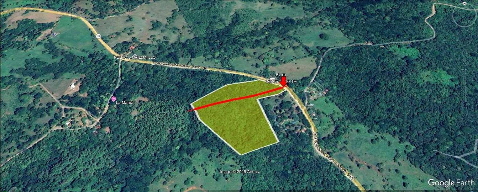
Featured property · Guanacaste, Costa Rica
Finca Marbella6.77 ha of land for sale · Guanacaste, Costa Rica
6.77 hectares (16.7 acres) on the Ruta del Sol, 2 km from the Pacific. Tropical dry forest, its own creek and land ready for a low-density project.
Price on request · we reply in 5 languages
- 6.77 haRegistered area
- 30Estimated lots
- 2.06 kmDistance to the coast
- 160Frontage on National Route
The opportunity
Land that has already done its homework
Finca Marbella is a 6.77-hectare property on the Ruta del Sol, on Guanacaste's northern coast, with gentle topography, a creek running through it and a tropical dry forest setting.
Its scale and conditions allow for a low-density residential condominium with a preliminary target of 30 lots, aimed at buyers who value nature and sustainability. Everything a developer needs to know before buying has already been researched: title, topography, water, watercourses, natural hazards and forest cover.
Ask for the price on WhatsAppEstablished tourist location
Minutes from Playa Marbella, San Juanillo, Ostional and Nosara, on the road that links the main destinations of the Nicoya Peninsula.
Easy land to develop
Average slopes of ~5 %, well below 15 %: ideal for lots, internal roads and gravity drainage.
Natural drainage solved
Manzanillo Creek provides a well-placed stormwater outlet, a requirement for any urban development.
Its own water model
Outside AyA coverage: the condominium regime allows applying for and managing a private well for self-supply.
A differentiated product
Low density, tropical dry forest and a homogeneous, sustainable architectural design that gives the community a unique character.
Property fact sheet
The facts, no fine print
Registry and technical information taken from Costa Rica's National Registry, the Cadastre and official government map viewers.

- Location
- Cuajiniquil district, Santa Cruz canton, Guanacaste province, Costa Rica. Near Playa Marbella.
- Access
- Direct frontage on secondary national route 160 (Ruta del Sol).
- Area
- 67,732.77 m² (6.77 ha / 16.7 acres) per cadastral plan and Public Registry.
- Title / plan
- Folio real No. 152744-000 · Cadastral plan G-1084053-2006.
- Current use
- Tacotal (regenerating vegetation).
- Topography
- Relatively flat; average elevation ~60 m above sea level; average slopes ~5 %.
- Surface water
- Manzanillo Creek, crossing the property from east to west.
- Distance to coast
- ≈ 2,064 m from the nearest point of the property.
- Airport
- Under two hours from Daniel Oduber International Airport (Liberia).
- Proposed concept
- Horizontal condominium of individualized primary lots (lot condominium), ~30 residential units.
8-page report with maps, elevation profiles and official sources. We send it to you after first contact.
Location & surroundings
On the Ruta del Sol, a stone's throw from the sea
The property sits on secondary national route 160, known as the Ruta del Sol, the road that connects the main beach destinations of the Nicoya Peninsula.
From the nearest point of the property there are at least 2,064 m to the coast: close enough to enjoy the ocean, and far enough to be outside the coastal strip and reduce the risk of saltwater intrusion into the aquifer.
- Playa MarbellaThe nearest beach
- Playa San JuanilloEstablished beach destination
- Playa OstionalWildlife refuge
- NosaraTourism & real-estate hub
- Daniel Oduber International Airport (Liberia)Under two hours by road

Explore the area on the map
The land
Gentle topography, ready to build
67,732.77 m² described as tacotal, with relatively flat topography that makes lots, internal roads and gravity stormwater management easy.
- ~60 mAverage elevation
- ~5 %Average slope
- < 15 %Threshold for lots & roads
- E → WCreek direction
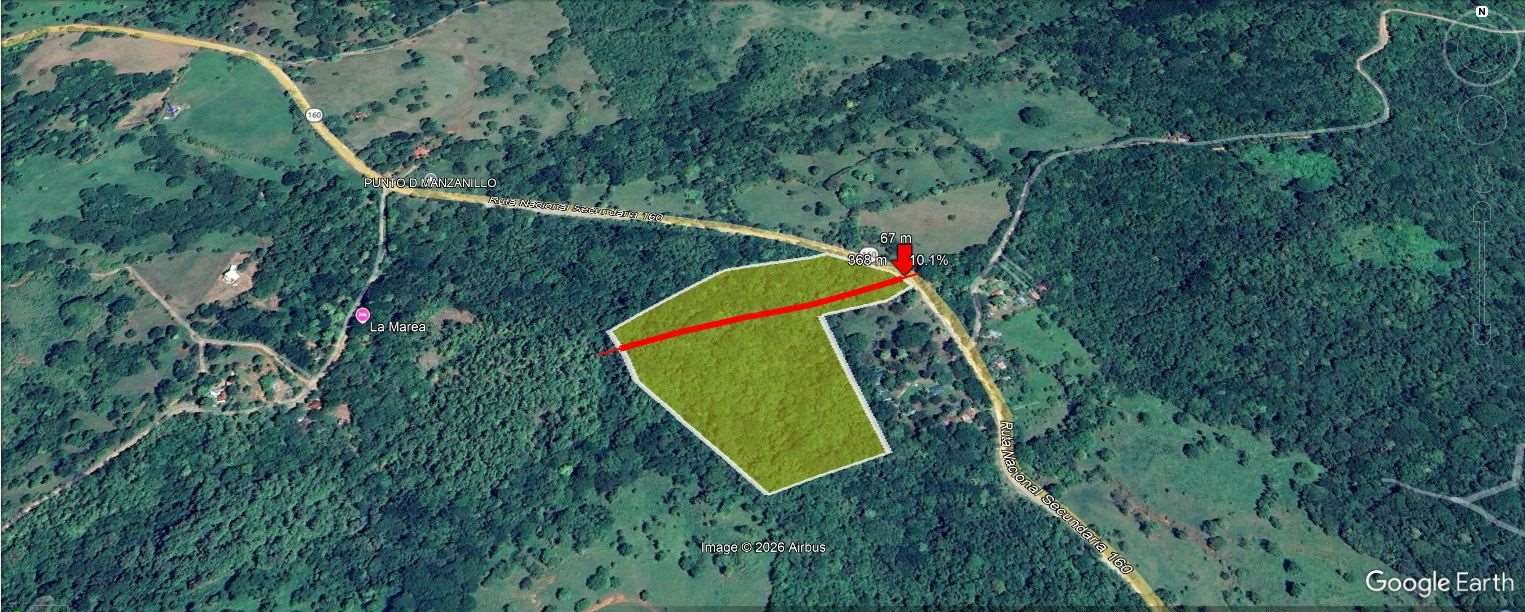
The northern part has an average elevation of about 60 m above sea level, with an average slope of around 5 % both east–west and north–south. The lowest area coincides with the bed of Manzanillo Creek. These slopes are considered ideal for developing parcels and internal roads, as they do not exceed 15 %, and allow stormwater to be channelled by gravity towards the creek.
- Distance341 m
- Elevation59–67 m
- Average slope5,4 %
- Maximum slope15,5 %
East–west elevation profile (Google Earth). Elevation 59–67 m, average slope 5.4 %, maximum 15.5 %.
- Distance304 m
- Elevation58–67 m
- Average slope5,2 %
- Maximum slope14,4 %
North–south elevation profile. The lowest point corresponds to the creek bed. Elevation 58–67 m, average slope 5.2 %.
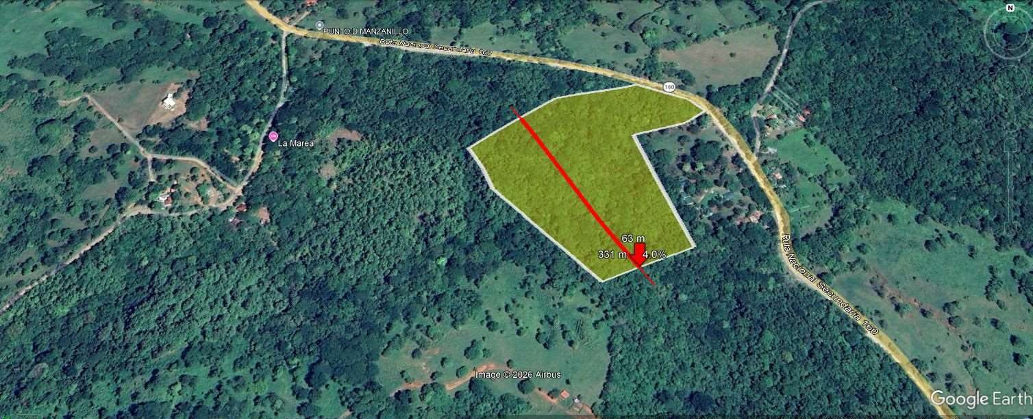
Profiles were traced in Google Earth over the highlighted property; values are indicative and must be confirmed by a topographic survey in the field.
Manzanillo Creek
Water that runs through your land
According to the official SINIGIRH map from MINAE (the Ministry of Environment and Energy), the creek crossing the property is Manzanillo Creek, a watercourse with its own micro-basin that flows into the Pacific Ocean.
For the project it is a double asset: it adds landscape value and serves as the final stormwater outlet, a requirement for any urban development.
The creek is expected to be public domain, so it would carry a 15 m protection zone on each side under the Forestry Law. This strip can be integrated into the project as a green corridor and common conservation area.
- Official watercourse identified on the SINIGIRH (MINAE) map, code 150103.
- Its own micro-basin, reaching the Pacific near Playa Nilo.
- Natural stormwater outlet for the whole development.
- Green corridor and common conservation area for the condominium.


Drinking water
A private well, with a legal framework
The Marbella aquifer is classified as a special protection aquifer and well drilling in the area is strictly regulated.
According to an official AyA (national water utility) letter from March 2026, the property is outside the aqueduct's coverage area, which opens the way to apply for a drilling permit and a private water concession.
Regulation for Drilling Permits and Water Concessions for Self-Supply in Condominiums: it allows a condominium to manage its own well. This is one of the main reasons for structuring the project under that legal figure.
The feasibility of the concession depends on a hydrogeological study showing that this flow does not affect the aquifer. The distance to the coast minimizes the risk of saltwater intrusion, and the design includes permeable surfaces and on-site stormwater infiltration.
Estimated project demand
- 30homes (5 residents on average)
- 1,500 Lper home per day (AyA standard, coastal towns 2021)
- 45,000 Lper day for the whole project
- 0.52 l/srequired flow, considered small

Environmental context
Every official layer, reviewed
We consulted the map viewers of the Santa Cruz Municipality, MINAE and the National Emergency Commission (CNE). Explore the layers that support the project's feasibility.
2,064 m to the Pacific
Santa Cruz municipal viewer with the measurement from the nearest point of the property (in purple) to the shoreline. Outside the coastal strip, with lower risk of saltwater intrusion.
Official watercourse with its own micro-basin
MINAE's SINIGIRH map: Manzanillo Creek identified next to Route 160, with a channel length of ~4.8 km to its mouth.
Special protection aquifer zone
The property (white arrow) lies within the Marbella aquifer zone and outside AyA aqueduct coverage, which enables applying for a private well under the condominium regime.

Flood zones outside the property
The National Emergency Commission was consulted on faulting, volcanism, flooding and slope instability; its April 2026 opinion is the standard for any project: a geological study with geotechnical analysis. On the municipal map, areas with flood potential (in blue) lie to the north and south, outside the property (in purple, centre).

2017 forest cover
On the official 2017 cover map the property appears within the forest patch. This map is based on satellite imagery and not everything it includes is forest in the legal sense (it also covers built-up areas). The real condition of the land, described in the registry as tacotal, is determined by a forestry assessment.
Project concept
30 lots between forest and sea
A low-density residential condominium under the regime of a horizontal condominium of individualized primary lots.
This legal figure provides the framework to control construction, protect common conservation areas and manage a private well. The master plan covers not only the subdivision but also the design of the homes, with a homogeneous aesthetic that gives the community a unique character and sustainable criteria in materials, climate-responsive design and landscaping.
Nature-conscious buyers who value the tropical dry forest landscape and its protection, looking for a second home or an investment in one of Guanacaste's beach corridors with the strongest outlook.
Sustainability strategy
- Tropical dry forest landscaping with native, drought-resistant species.
- Efficient wastewater treatment to return water to the land at high quality.
- Rainwater harvesting for non-potable uses (irrigation, toilets).
- Solar panels to support electricity consumption.
- Permeable surfaces on roads and sidewalks, and on-site stormwater infiltration.
Gallery
See it from above
Satellite imagery, elevation profiles and official maps of the property and its surroundings. Tap any image to enlarge it.
Transparency
Current status and next steps
We tell you exactly what is resolved and which studies fall to the developer. That is how you buy with confidence.
Water
Outside AyA coverage. The private well concession is subject to a hydrogeological study; the final number of units will be adjusted to the well's actual capacity.
Forest
The land's classification is subject to a forestry assessment.
Geotechnics
Geological-geotechnical study required by the CNE, standard for any project.
Cadastre
Cadastral plan being updated. The public road shown on the northern boundary does not exist in reality; the effective frontage on Route 160 would be 90.45 m, sufficient for the development.
Technical source: Report on land conditions — Finca Marbella, prepared by architect Oscar Villavicencio B. (May 2026) from public information of the National Registry, MINAE, CNE, AyA and the Santa Cruz Municipality. For information purposes only; it does not constitute a binding offer. Areas and locations on digital maps are indicative and must be confirmed in the field.
Frequently asked questions
What every buyer wants to know
How big is Finca Marbella and where is it?
It measures 67,732.77 m² (6.77 hectares / 16.7 acres) per cadastral plan and Public Registry. It is in Cuajiniquil district, Santa Cruz canton, Guanacaste, Costa Rica, with direct frontage on national route 160 (Ruta del Sol), near Playa Marbella.
How far is it from the beach?
About 2,064 m from the nearest point of the property to the Pacific coast: close to the sea, yet outside the coastal strip and with lower risk of saltwater intrusion into the aquifer.
What is the price?
The price is shared directly with interested buyers. Message us on WhatsApp at +506 8858 5820 or fill in the form and we will reply with the price, terms and the complete dossier.
Does it have water?
The property is outside AyA aqueduct coverage (official letter, March 2026), which allows applying for a drilling permit and a private concession under decree 35271-S-MINAE for self-supply in condominiums. The concession is subject to a hydrogeological study. In addition, Manzanillo Creek crosses the property from east to west.
What can be built?
The proposed concept is a horizontal condominium of individualized primary lots (lot condominium) with a preliminary target of 30 low-density residential units. The final number will be adjusted to the well's actual capacity and the corresponding studies.
What is the topography like?
Relatively flat: average elevation of about 60 m above sea level and average slopes of around 5 %, well below the 15 % recommended for lots and internal roads. The lowest area coincides with the creek bed.
Are there natural hazards?
According to the municipal map that integrates the National Emergency Commission's layers, areas with flood potential lie to the north and south, outside the property. As for any project, the CNE recommends a geological study with geotechnical analysis.
Is it titled and up to date?
Yes: folio real No. 152744-000, cadastral plan G-1084053-2006. The plan is being updated; the effective frontage on Route 160 would be 90.45 m.
Can a foreigner buy it?
In Costa Rica foreigners can acquire titled property with the same rights as nationals. Finca Marbella is titled property outside the maritime-terrestrial zone. We recommend working with a lawyer-notary; we can put you in touch with trusted professionals.
How can I visit?
We arrange on-site visits and virtual tours. Indicate it in the form or message us on WhatsApp and we will agree on a date.
Contact
Let's talk about your next project
We reply in English, Spanish, German, French and Italian. Pick the channel you prefer or tell us about your interest in three steps.